A free self-guide map version of the trail is available from the Lancashire Mining Museum.
Please see lancashireminingmuseum.org for opening times.
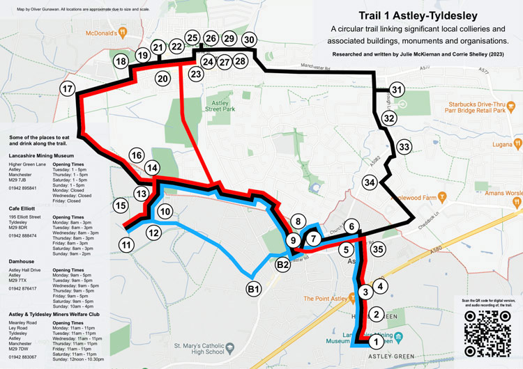
Trail 1: Astley-Tyldesley
An approximately 2 hour* circular walking/cycling route of 5.3 miles / 8.5km involving some off road footpaths. *Allow extra time for sharing information at points of interest.
For shorter route take Option A (Blue Route) an approximately 1 hour* circular walking/cycling route of 3 miles / 5km involving some off road footpaths. *Allow extra time for sharing information at points of interest.
For shorter route take Option B (Red Route) an approximately 1 hour* circular walking/cycling route of 3.5 miles / 6km involving some off road footpaths. *Allow extra time for sharing information at points of interest.
Downloads:
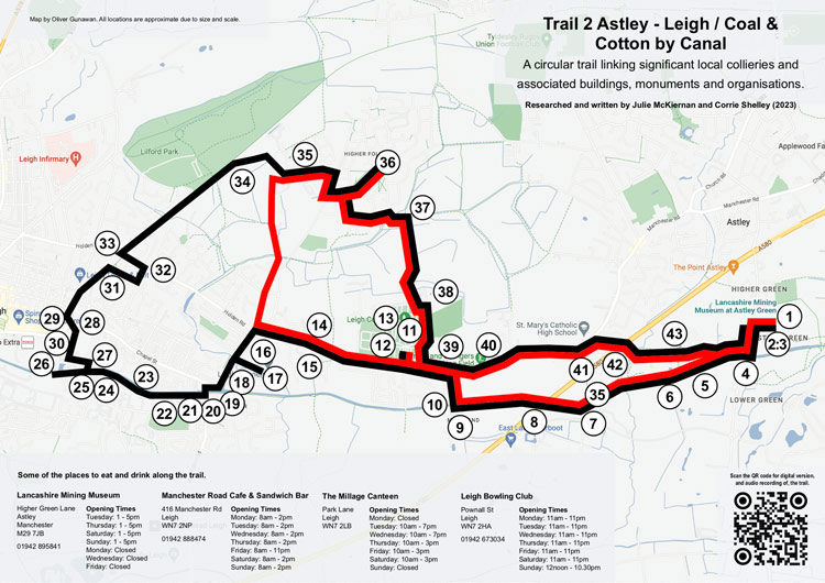
Trail 2: Astley - Leigh / Coal & Cotton by Canal
An approximately 2.5 hour* circular walking or cycling route of 7.5 miles / 12 km involving some off road footpaths. *Allow extra time for sharing information at points of interest.
For shorter route take Option A (Red Route) an approximately 2 hour* circular walking or cycling route of 5.6 miles / 9 km involving some off road footpaths. *Allow extra time for sharing information at points of interest.
Downloads:
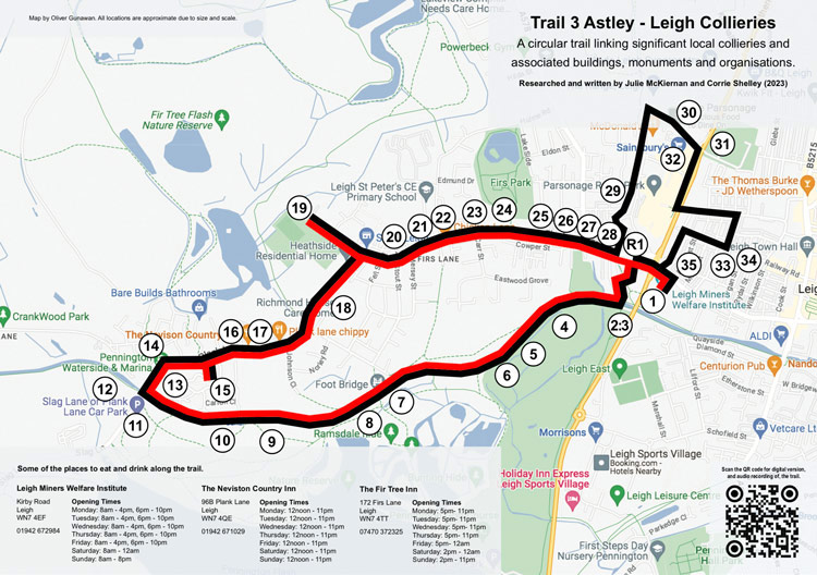
Trail 3: Astley - Leigh Collieries
An approximately 1.5 hour* circular walking/cycling route of 4 miles / 6.5 km involving some off road footpaths. *Allow extra time for sharing information at points of interest.
For shorter route take Option A (Red Route) an approximately 1 hour* circular walking/cycling route of 2.8 miles / 4.5 km involving some off road footpaths. *Allow extra time for sharing information at points of interest.
Downloads:
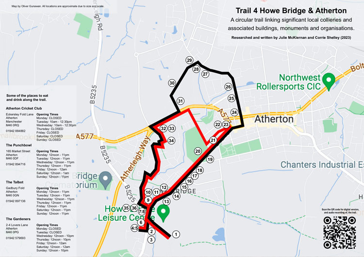
Trail 4: Howe Bridge & Atherton
An approximately 1 hour* circular walking/cycling route of 2.8 miles / 4.5 km involving some off road footpaths. *Allow extra time for sharing information at points of interest.
For shorter route take Option A (Red Route) an approximately 45 minute* circular walking / cycling route of 2 miles / 3.5 km involving some off road footpaths. *Allow extra time for sharing information at points of interest.
Downloads:
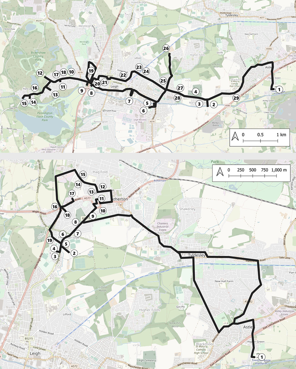
Disability/Vehicular Access Trails
Suitable for people who wish to follow the trail in a vehicle.
Downloads:
Trail 1: Astley - Tyldesley
Trail 1: Disabled Access word DOC
Trail 1: Disabled Access Map JPG
Trail 2: Astley - Leigh / Coal and Cotton by Canal
Trail 2: Disabled Access word DOC
Trail 2: Disabled Access Map JPG
Trail 3: Astley - Howe Bridge & Atherton
Trail 3: Disabled Access word DOC
Trail 3: Disabled Access Map 1 JPG
Trail 3: Disabled Access Map 2 JPG